Aerial photos & video
Property imagery for listing presentations, websites, and social posts. We agree on the shot list, formats, and intended use before the flight.
Luke Elston · Crossville, Tennessee
Aerial imagery that shows how a home sits on its land — before a buyer makes the trip.
My own Crossville home · actual drone footage
Selected property work
The house, the driveway, the tree cover, the space around it. These examples come from a capture of my own home in Crossville, showing how an aerial view can help someone understand a property from a distance.
Personal demonstration, not a client listing. I flew the capture and directed the processing and presentation.
Looking for tools for your team? Explore five custom software ideas.
A short aerial orbit puts the home and its immediate surroundings in the same frame. Silent footage.
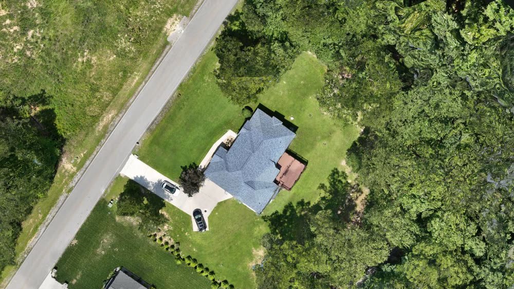
An overhead image makes the relationship between the building, road, and landscape easier to see.
A visual overview, without property-boundary or measurement claims.
View the overhead imageFor a home, it may be the setting. For acreage, the relationship between open ground, tree cover, and visible access. We choose the useful views first, then agree on the capture and delivery.
Property imagery for listing presentations, websites, and social posts. We agree on the shot list, formats, and intended use before the flight.
Show the building in context and give distant buyers a clearer view of the setting. The capture follows the property and the questions you need to answer.
A focused property page bringing imagery, approved property details, and your contact information together in one link.
Serving Crossville, Fairfield Glade, Lake Tansi, and the surrounding Upper Cumberland. Commercial flight work is handled through Atlas Geospace; flight conditions, permissions, scope, and delivery timing are confirmed before booking. Visual models are not boundary surveys or engineering assessments.
About Atlas GeospaceI can build custom software around the way your team works: presenting a property, preparing a listing, or keeping the next follow-up from slipping through.
Five examples we could build together. Each starts with your workflow and a defined scope.
Enter the property details once. Combine them with your photos and video to prepare a property page, a flyer with a QR code, and draft social posts and an email announcement. Review everything before it goes out.
Property details & imagery Your review Marketing materials
Give distant buyers one link with aerial views, clickable points for buildings and other features, and supporting documents. Use your approved information to explain the setting and answer the questions that photographs alone leave open.
Aerial views & property knowledge An interactive property guide
Connect a property page to your existing customer-management system. Bring the buyer’s question, the property they asked about, and the next follow-up into one place, with a reminder if it still needs attention.
Property inquiry Assigned agent Follow-up task
Bring available showing feedback, inquiries, marketing activity, and your notes into a concise weekly draft. Check the sources, add your recommendation, and approve the update before sharing it with the seller.
Activity & notes Draft update Your approval
Record a quick voice note after a showing. Turn it into suggested buyer notes, tasks, and a draft follow-up. Confirm the right buyer and property, then save the details while they’re still fresh.
Voice note Notes & tasks Your confirmation
Show me the repeated work. We’ll check what your existing tools already handle, what access is available, and what a useful first version should do.
Send me the location and what is difficult to show in the listing. I’ll suggest a useful first deliverable and quote a defined scope.
A personal 3D demonstration, not a finished listing-tour product.
The building reconstructs well; the surrounding ground and vegetation have visible gaps and uneven edges. This example shows the direction of the work. It does not demonstrate a complete property or an interior tour.
My portfolio includes a commissioned industry-briefing tool, built around the information its readers needed. See what I contributed and where each project stands.
See the software workI’ve also turned my family’s farm into an explorable VR environment. The long ambition is to let your great-great-grandchildren walk a place as it was. That personal exploration is where much of this capture work began.
Explore the farm project